


Beautiful sunrise at 04:30 before leaving camp 15 on July 16.

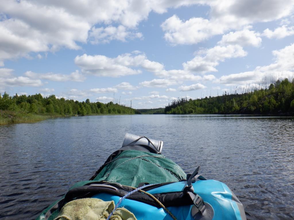
Gorgeous day with white cumulus clouds in a blue background, great to see a normal looking sky after the heatwave. This location is the upper end of the long bay leading to the new target, where hopefully I will find a winter trail to start the portage through six small lakes to reach the desired river valley destination. Seen in the distance directly in line with the canoe is the dark green bump of the island where I first stopped to rest after leaving camp 14 six days ago.

Closing in on the island bump, it is obvious how steep it is.

The view across the lake towards the area of unnamed lake 9.6 where the bear took my butter.

Stopping at the island bump for a pee break. This is the long shallow rock point where, sweat-soaked, I cooled off after leaving camp 14. The only possible campsite is the area behind the point, but a hard luck one that I may have to use if a better one cannot be found.

Approaching the narrowing of the long bay, it is evident how the bush is largely regrowth after the extensive forest fire of 2008.


Getting close to the end of the bay, I can see that the incoming creek should be on the left, beside the steep bank on the extreme left. A trail if present should likely be to the right side of the creek (though I have seen trails that hug such a steep cliff).


As I paddle towards the shore I can readily see the creek exit, so I nudge the canoe as close as possible into the boulders through which the small stream flows, with thick brush on both sides.

Walking up the creek, I am able to step on rocks and boulders for most of the 300 metre length to view its small lake source, though having to zigzag through brush and cross one muskeg area where the stream wanders in multiple spots. I explore the bush on both sides of the creek but see no evidence of an old portage. Cutting a trail would be possible but a lot of work.


Going back to the canoe, hungry for lunch, I check the area nearby for a good place to sit, but nothing suitable so decide to eat in the canoe, sitting on my PFD over the stern thwart.

Activating the SPOT™ device is intended to show the reach of my travel today, and that I was checking for a portage. A later SPOT™ wherever I camp down the lake should help to confirm that.


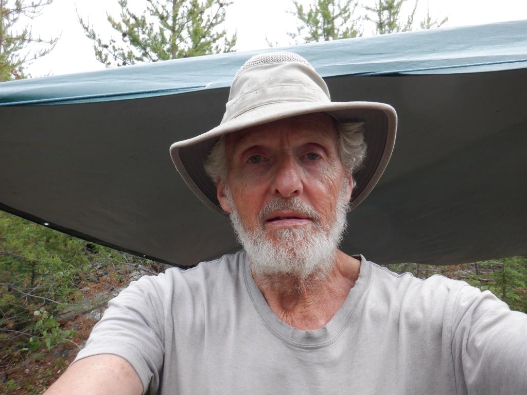
Quiet company on my hat while eating lunch.

Having searched the left side of the creek, if there is a winter trail it will likely be on the right so I paddle along shore and notice one possibility where I come back after checking farther. Yay, landing to the left of the tall birch tree in the photo, there looks to be a definite trail. (The track through the reeds is where I had just backed the canoe, but then paddled out again to take the photo.) Like many winter trails, there is no marker to indicate start and end, so sometimes it takes a vigilant and suspicious eye to locate.


Keeping a lookout for a campsite along both shores, I paddle back down the lake. Checking three of the small islands recovering from forest fire, I find a good location where I first noted the possibility.


Late afternoon on July 7, looking towards the far mainland shore, a nice day after earlier rain.
Video of camp 16's layout and setup.
**********************
Summary:
Move camp to a new location 13 km away, but paddle an extra nine km to find and check the next portage. First, disappointment in searching for a path, but then elation when a winter trail is located. Have to canoe back down the lake to find a campsite, but very happy to find a good spot, albeit requiring extensive clearing. Beautiful weather is a welcome change from the heatwave. Video of camp layout and setup.
July 6:
Temperature a nice cool 8°C at camp 15 when I arise at 03:00. After stopping twice for a break, I head past a group of small islands at the entrance to the upper narrowing end of the long bay, where I hope to find a trail to ultimately take me to the target river valley. I note a prospective campsite at the first island but hope to find a spot closer to the portage, so I do not stop to investigate. For a moment I wonder if it would be a location from which I could safely camp to then head through unnamed lake 9.6 to avoid using the bear-took-coolers-camp. It would entail more work and travel to be able to clear the two trails and pre-portage two barrels ... but I have already made a decision to change my route plans so discard that idea. Moving on, I get a bit confused in one place, thinking I am in a different spot than I really am, when I have to start making the map appear to fit the landmarks instead of the landmarks fitting the map. From my journal: "Don't know where I am exactly, but not lost." Passing a larger island which has some live tall spruce trees, it looks like another possible campsite. A moderate tailwind helps push me on as I keep an eye out for campsites, but the shores are mostly quite steep, some too low and brushy. Finally I reach the end of the bay and the creek that empties the first (the lowermost) of three small lakes that the map shows drain through each other to the bay. The creek is shallow, very rocky and bouldery. Checking the first 50 metres on both sides of the creek, I cannot find even a vestige of a trail, but this area has all been burned and is growing back with small trees and thick brush. I walk up the creek on the rocks and boulders all the way to the small source lake, about 300 metres. From my journal: "Disappointed. Would be a big job to cut a trail on right hand side of creek. However the creek meanders and there is a section higher up that a trail would have to bypass making the trail even longer. Of course I'm not done looking for a portage yet; could be farther away from the creek, not on the left hand side with the steep cliff." Back at the canoe, I activate the SPOT™ at 11:30, and eat lunch sitting on the rear thwart, looking over the lake, my back to the hot sun. Paddling out into the lake I canoe about 100 metres along the shore, spotting a suspicious area in the thick brush. From my journal: "Stop, turn around, back canoe in and tie up ... always tie up! It is a trail, a winter trail probably. I'm smiling now. Walk the entire path, throwing off the occasional branch or breaking back a small tree. It's in good shape, mostly traversing small regrowth pine. Some larger down trees have been sawed out in earlier years. Upper 50 metres goes across muskeg through thick Labrador tea. On the return I step off 340 metres (Barry metres). No bear scat. No campsite. Had been thinking if I have to cut a trail, closest camp might be the mountainous island five km away, a long commute. Chances are, because there is a winter trail, then probably (hopefully) will be similar trails between the six small lakes to the target river valley, seven trails in all, another reason to smile."
On my return down the lake to look for a campsite, I have to face the wind that brought me, now a headwind. Scanning the two shores of the narrow bay all I see is steep shoreline, but I keep an eye out for the larger island with tall spruce trees where I want to investigate. Because I am now unknowingly on the opposite side of the island from when I came in, I canoe right past the spot, thinking that it is mainland. When I get past, I realize my mistake so I turn back to the other side to make sure it is an island and the correct one, now recognizing the tall trees on the upper side. Landing at the area that from the other side I thought was too steep, I soon confirm it is plus there are many down large tall spruce crisscrossing the ground with no level spots except at the top of the hill. Tramping around, it does not take very long to decide this is not a good campsite for any of the key elements. Now I canoe down the lake to the area with the group of small islands, none with mature trees but I had noted a promising location on the way in. If it does not prove out, then I will be stuck with the hard luck camp on the mountainous island. In the middle of the island group I check a small island that looks okay from the canoe but not so when I land. From my journal: "As often at this time of day, I am chanting 'Come on campsite, Come on campsite, ...'; it does not always help. When I stop it sure looks encouraging. Good access to water, not too steep mostly bare rockface shore, tall enough pine tree regrowth for shelter. Two good areas for fireplace, one farther inland if protection from wind needed. A good place for Tarp shelter, after removing trees. Lots of down fire-killed firewood. Walk inland to a somewhat open levelish area, thick tall Labrador tea at one end (awful to have to pull or cut out - can't set up tent on it - tried once); more open at the other end but needs levelling with axe head, removing logs and stumps and cutting out some pine trees and branches. Smiling I say 'A good spot!' Need to cut a trail about 50 metres from shore where canoe is landed so I can carry gear to tent. There's a spot on shore where canoe can park after removing two trees. Smiling again 'A good site!' Wonder what it looked like prior to the fire of 2008? Enough stones for fireplace. Don't see evidence of an old stone fireplace though." Camp 16 is on a small island 13 km from the previous site but I have travelled an extra nine km to find and check the next portage for a total distance paddled of 22 km.
The first thing to do is put up the Tarp shelter, even though a beautiful half clear sky and bright sunshine. I fell about 20 pines, some birch and spruce, the latter set aside for a mat under the shelter. Because the pines, although tall enough, are not adequate in diameter to support the ridge rope when pulled taut, I reinforce the two anchor trees with ropes stretched to other pines. There is no end of trees to use to hold the bottom side of the Tarp. Next I clear a spot to park the canoe and store gear not needed in camp. Now I cut a path to the tent site through thick pines and some spruce which I set aside for the Tarp shelter. The trail is Y-shaped, one arm to shore where the tent gear is unloaded and one to the Tarp shelter from the tent. Then I clear and level a spot for the nylon tent, using the axe head to root out roots sawed or cut out with pruners, and fell some pine, spruce, birch and alder. It is 17:30, three hours since landing and starting SPOT™, about half that time spent clearing. Finally I make a fireplace to boil water. Thankfully I brought a large Ziploc® bag full of birchbark for tinder from last camp as it can be hard to find in burned-over areas like this. However, I do see a dead section of birch about 100 metres along the shore if needed. (I do have other means of tinder for starting fires as backup in my gear that I rarely have to use.) By evening the sky is grey, completely clouded over. I place all the spruce boughs underneath the Tarp shelter to keep dry, after pruning some to layer on the loose brown soil in the tent front vestibule. Hungry, well past usual supper time, my meal is macaroni and cheese, a pot of hot water, fresh fireweed tops, two protein bars. As often the case, there is no time to write my journal on move days; that waits for tomorrow. In bed by 21:00, laying on bed sheet dressed only in pajama socks and undershorts, I wake chilled at 22:30 to put on pajamas and crawl into fleece shell. Sleeping well, it rains shortly after bedtime and several times during the night, my favourite time for rainfall.
July 7:
Sleeping in until 05:00, the breeze has almost dried the tent after last night's rain. It is 18°C, very cloudy and looks like more rain, so I move the fireplace close to the Tarp shelter where it is also better protected from wind. There is a light rainfall for half hour while I am baking bannock. Later I make a second bannock, improving and now settling on the best? way to prepare it without butter; I use the same procedure of two separate layers of dough with raisins, cinnamon and brown sugar in between (now with no butter) but add four teaspoons of water sprinkled on top of the sugar which seems to help keep the centre moist and tastier. Temperature rises to 23°C with a moderate wind and half white clouded sky. There seem to be no bugs much here at all, probably because of the wind exposure and not much undergrowth. Pre-packing to move on tomorrow, I am in bed by 20:00 and sleep well, very pleased at finding such a good site.