
Unnamed lake 10 viewed from the portage cut yesterday from unnamed lake 9.6.
Launching on unnamed lake 10, I have to determine the best location to cut a portage to the target river.


In the upper three photos are areas that I check before finally deciding on a landing spot, preferably a dry location. My bearing line is somewhat left of the upper end of the lake. I land on shore in the third photo after noticing the bit of exposed rock face well behind shore at the edge of the tall bush thinking it might be a good spot to place gear and have a lunch fire. However when I get on shore, it is very boggy, my boots getting wet up to the tops, just barely keeping dry feet by jumping from hummock to hummock, not a good spot. I walk inland on drier ground making my way to the left, finally deciding on a good landing, marking it with a piece of orange flagging tape. Back to the canoe I then paddle out into the lake and over to the flagged spot.


I then mark the landing more permanently by cutting off the side branches of a small jack pine tree closer to shore. There are no large live trees that can be blazed.


There is a deep wet spot near the canoe that I fill with some brush so at least I do not go over the top of my boots, provided I do not stand in one spot very long. I leave my gear in the canoe, covered with a tarp in case it rains.


I cut a path over the soggy ground to a small area of boulders, surrounded again by wet bog. After working to start cutting the portage trail through the bush I come back to make a lunch fire to shoo blackflies. The fireplace itself is surrounded by very wet ground; I must be careful where I step and for how long to avoid getting too wet. There are dead trees suitable for hanging sweaty clothing nearby. Beside the fireplace there is a boulder on which I can sit in a dry place while I eat lunch.


After lunch, I cut and clear a trail up the slope. By "clear" I mean that I toss off branches, logs and stones in my path. Note that in some spots, I place logs to step on and up when carrying heavy loads. The steep rockface proves the value of sturdy leather boots with Vibram soles.

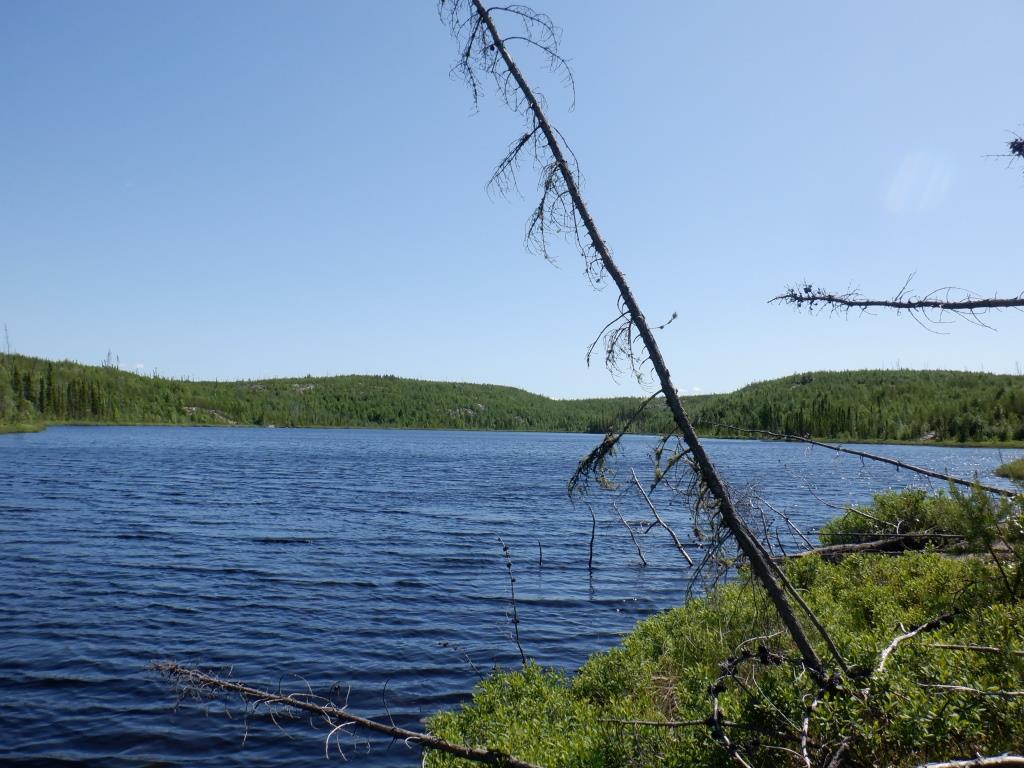
Looking back down the hill, after clearing 300 metres of trail, I can see the three lakes, the first being unnamed lake 10, the middle one unnamed lake 9.6 and the farthest one, the big lake where I motored from the cabin.


Moose droppings on the portage trail, evidence that a moose was here last winter to dine on the plentiful birch and alder trees grown since the fire of 2010.
**********************
Summary:
Second day of cutting a portage, now the start of a trail which will be at least one km long. Hot sunny day. Wear headnet all day because of blackflies. Discussion about orientation with compass and GPS. Distance travelled by motorboat 22 km (11 km and return), portage canoe eight metres, paddle one km on small unnamed lake 9.6, portage 250 metres, paddle one km on unnamed lake 10, start cutting a portage towards target river, 300 metres up a steep hill that rises 23 metres.
July 4:
Up by 4:30 a.m. to a clear sky, I have slept in, giving Wilson a rest from waking me at the usual 3 a.m.. I hang up all sleep gear and yesterday's still damp heavy socks on my cabin clothesline. Socks are so important for healthy feet; I rotate between three pairs between doing laundry, and carry a total of nine pairs of "Marks T-Max® HEAT™ Socks", which are quite thick and cushiony. Before leaving in the motorboat by 7:45 a.m., I fell and trim a three metre birch pole to store in the boat. It takes 30 minutes to reach the eight metre portage, a fast trip for the 11 km distance. The first thing I do is check the canoe hull for integrity; bears have been known to damage non-aluminum canoes, although so far never one of mine. I minimize any attractants, not placing fish directly on the canoe surface, using a layer of moss to lay the catch on when fishing from the canoe. It takes one hour to paddle the one km distance of lake 9.6, portage two loads the 250 metre trail cut yesterday (canoe and two packs, paddles, painters), then canoe one km to the upper end of unnamed lake 10. So I need to allow 1-1/2 hours travel time back to the cabin; ideally I will reach camp by 3 p.m., meaning I need to leave by 1:30 p.m.; should have risen earlier, but I was tired. Launching in lake 10 for the first time ever, I scan the entire upper shoreline and the hills behind for the most likely landing place. Consulting map and compass, I can see the area matching where my bearing line is drawn. As usual though, I check to right and left, in the unlikely event here, that there is some evidence of a previous portage. Also I must find a reasonably dry area if possible to land and set up a lunch fire spot to be used each day that I am cutting trail. The first place I check is the attractive looking copse of black spruce untouched by the forest fire. Everything else around, as far as the eye can see, is new growth since the forest fire of 2010. I know the spot is too far to the right for my bearing, but the land behind rises lower than elsewhere except for the far left corner. [I do refer to directions by compass points, but that is not useful for the reader when looking at the photos.] Just to the left I notice a patch of exposed rock face inland at the edge of the bigger bush; it might be a good place to have as a base. However, when I land, to reach the rock, I have to walk on very very wet muskeg for about 20 metres; I almost get water over the top of my boots several times, stepping and jumping from hummock to hummock. Once along the bottom edge of the hill where the taller trees are, I walk farther inland and to the left to skirt the worst of the muskeg. Walking is difficult through and on the thick Labrador tea brush in the deep moss. Closer to the lake, there is a patch of stones and boulders which eons ago were under the lake. They are in the midst of wet muskeg with pools of water, but there are a few small "island" places with elevated boulders. From here there is a drier approach to the lakeshore, not dry but much better than where I landed, so I mark a dead tree with orange flagging tape. Directly inland is a bit of a draw up the hill that looks promising for a portage trail. Walking back to the canoe, I paddle to the left past the flag to check a dry looking location that also has some boulders, but I think it is too far to the left. Back to the flag, I land and the first thing to do is to build a small fire to chase blackflies. There is not much birchbark here so will bring some from the cabin next trip. From two small birch trees I gather a small pile of bark pieces that fit easily into the palm of my hand to light the fire, with some small dry twigs from a fire-killed tree for kindling. Soon I have a fire going, which I keep fueled all the time I am here. Rinsing my headnet and sweat-soaked bandana and handkerchief in the lake, I hang them to dry on nearby dead trees; I wore the headnet to do the earlier portage, blackflies bad, especially because I was sweating. After lunch (two mints, LifeStraw® water, quarter cinnamon bannock, cheese, almonds, two protein bars, gum) I don the headnet again to start cutting the portage. A GPS reading is almost bang on the map grid reading for the bearing line I drew at the shore line of unnamed lake 10, so I am really happy about that. The little dip of land up the hill behind the campfire really looks promising and is in direct line of my map bearing line. My trail follows in part a game trail. The hill is generally steep, worse in some places, but that is expected from the contour lines on the map. There is not a lot of cutting to do as I follow the "path" up the slope. There are some steep 45° rock faces so I lay down burned logs as steps in a few spots. I can walk up these places now, but not easily when carrying heavy loads, which would risk injury. If the rock faces are wet and slippery, it could be a difficult ascent. Reaching near the top of the hill, at least past the steepest parts, I have cut 300 metres (300 paces) of trail, a good start. A GPS reading shows me on the correct bearing and the altitude to be 23 metres above the lake below, matching the two 10 metre contour lines, helpful confirmation I am on the right track. Having decided I have made and blazed a trail as far as I will go today, I walk to the left through some thick jack pines to a little valley about 400 metres away to see if there are any signs of an old portage. Some of this valley was spared the forest fire because of the muskeg. I put up a female spruce grouse, fittingly amongst black spruce bush; there are no young visible, unless she is still on a nest, not likely. The valley floor is very very thick spongy moss with lots of Labrador tea, hard walking, no sign of a trail. So far I prefer "my" location for a portage trail; I feel good about my choice. After working hard for over three hours, my clothes are sweat-soaked, down to my undershorts, even the top of my jeans and leather belt. Once reaching the boat, I remove my headnet as the speed of travel leaves blackflies behind, something not possible in a canoe. Near the cabin, I try fishing for a short while, hoping for a quick catch, with no luck. When I get back to camp by 3 p.m., I hang up my wet shirts and hat, plus newly rinsed bandana and handkerchief which dry quickly. I am quite pleased to see that the sleep gear and damp clothes hung in the cabin all day are nicely dry. At 4 p.m., I have to rescue the clothes from the line when it becomes very cloudy and a threatening thunderstorm moves through nearby with very little rain on camp. It has been a hot 25°C sunny day until now. Thunder rolls continually all around me for over three hours, but then at 7:30 p.m. the rain starts in earnest and continues heavy all night. During the day I drank lots of LifeStraw® water before and during lunch, plus a canteen full on returning to the boat; at supper I drink the whole three litre medium pot of hot water. Weary and tired after the day of fresh air and exercise, to bed by 9 p.m., I sleep well with no leg cramps.
Discussion about orientation with compass and GPS:


At home when planning this trip, I decide what I think is the best place to make my way to the target river. On the topographical map, I have drawn a straight line between the two points from unnamed lake 10 to the river, the distance being one km "as the crow flies" (in this case the "raven"). I record the Universal Transverse Mercator (UTM) grid bearing, expressed by two sets of numbers (combined into one long number), which indicate the specific plot of longitude and latitude, unique for that location on planet Earth. Using the map and compass while in the canoe on unnamed lake 10, I identify what best matches the spot on shore to the bearing. Then, using my Global Positioning System (GPS) device ("Garmin® eTrex® 10 GPS") I will take a reading at that location to see how closely it matches the map grid bearing. The GPS not only gives the longitude and latitude reading, but also the altitude which can be compared to where my bearing line crosses map elevation contours to see if they match. It all sounds more complicated than it is. You need to practise beforehand; as always, "anything is easy if you know it". When there are obvious landmarks, as in this case, map and compass are the most important tools, but the GPS gives confirmation and reassurance. Once I am satisfied with a direction of travel, I take a bearing on some type of promontory, usually a tall tree that is easy to keep track of as I cut a trail through the bush, such as the one in the photo above. Of course, do not confuse one tree with another, obvious disclaimer. As I progress across the terrain, I take compass bearings on other distinctive landmarks. Each day at the end of cutting trail, I perform a GPS reading to check how close the trail is to my bearing line. It will also let me know how I have progressed, and more importantly how much farther to the target. Initially when I started creating long virgin trails I tried walking to the target point and blazing a path, often very challenging through thick bush; after gaining confidence I just started cutting the portage, trusting in my orienteering skill. However, as I proceed I often do walk ahead to find the best route, sometimes clearing the trail backwards, or blazing trees to mark the best way. I do zigzag to avoid obstacles, but when zigging, trying to zag the same amount to keep on track.
The compass dial is set to the bearing decided from the map. Then when using the compass its line of sight is directly on the bearing when compass is oriented to the north point as usual (compass adjusted for annual declination). I use the "Suunto® MC-2/G/6400" compass, better than the "SILVA" brand because it has a higher needle so does not get "stuck" when not level. (It works for southern latitudes which is why the needle is higher.) Before I knew how to use the bearing method, I once spent several hours cutting a trail which ended in the wrong place; I did laugh out loud, calling it my trail to nowhere. Good thing my son was not there; he would not have been amused.