


July 7 sunrise (03:50 - 04:35).


A beaver swims past just before I leave camp 12 (05:08).


Heading down the lake towards the long bay in Manitoba (05:50, 06:13). Because it is so calm I paddle the shortest course mid-lake. So far from shore landmarks it seems to take forever to make headway.


Stopping for a break at 07:09, fireweed in bloom (at the island identified on July 5 as a possible campsite.)

At 08:30 I reach the opening of the bay running farther into Manitoba, but here is where I turn north (left) towards the Churchill River.


Interesting exposed rock formation along shore.

Stopping on an island for lunch at 11:13.


Moving on again on this very large sprawling lake at 12:07.


12:18 - 13:13, approaching the island where I stopped in 2017 to be flown out because of forest fire blocking my route. At that time I was in the middle of a circle route heading south to canoe out the way I have just paddled in.


I had planned on camping here but the tent site is strewn with large fallen trees, evidence of strong winds. The Grumman aluminum canoe is crushed under one of the trees.

After travelling an extra four km to investigate five other locations on islands nearby I finally find a campsite on a large island. Interestingly it was closest to the first island I checked but I overlooked it in favour of going the other direction.

I explore the jutting point which is too open and covered in bristly raspberry canes. About 100 metres along the shore I spot a raised area behind trees; I realize it will be satisfactory with places for tent, Tarp shelter, canoe and fireplace.


Camp 12 requires cutting out brush and trees to allow access and to create enough space.


The point is a perfect place to fish and bathe.

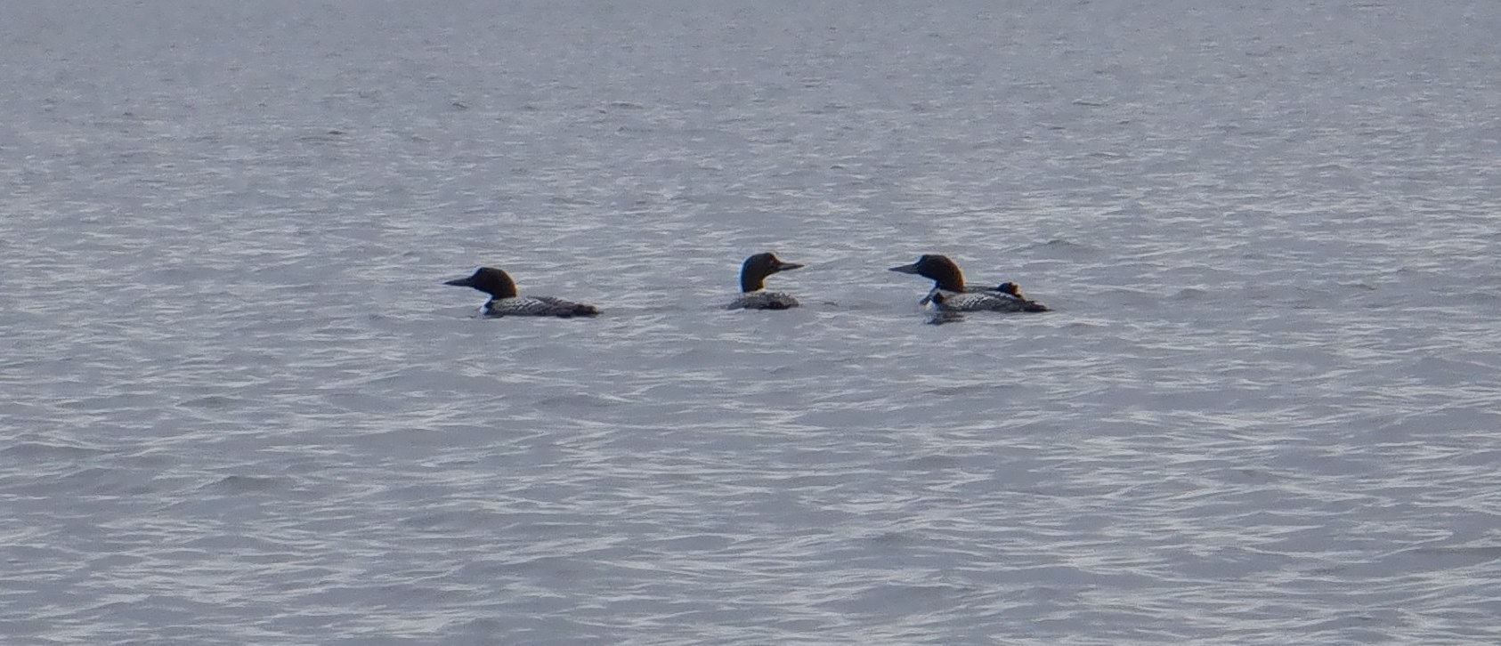
Four loons swim past camp. (One is underwater when this photo taken.)


About 20 double-crested cormorants swim very near; I am too slow with the camera and they fly farther away after spotting me.


July 8, a hint of smoke on the northeast horizon.


July 9, a thunderstorm moves through.
**********************
Summary:
In keeping with my luck so far, planned campsite is not habitable because of large down trees. Cached Grumman canoe has been flattened by a huge spruce. Travel an extra four km to investigate five other locations on islands nearby. Finally find a new campsite which requires significant clearing. Travel a total of 23 km, including the extra four plus three when I take the wrong route. Camp 12 is on an island in Manitoba two km east of the Saskatchewan border. Large number of cormorants and pelicans fish together. Erect the Bug Tent to escape horseflies in the 30°C heat. This season's first forest fire smoke.
July 7:
Up to the alarm at 03:00, I make a small fire to shoo bothersome blackflies. Fortunately it works because there had been hundreds waiting to accompany me to the canoe. The sky is clear and I can see all the way down the long bay into Manitoba, mirroring the bay to the west that I am leaving behind. It is calm so I paddle straight down the middle; the disadvantage of being so far from shore - no feedback of how fast I am moving compared to when landmarks are close by. From my journal: "Go past the islands I checked on the way in towards the long portage. I miss seeing the channel where I will head south on my return. My mind must have been on idle, arms just moving their usual one stroke per second. I think I know where I am but have that feeling that I'm not so sure. It's a hint of pre-panic I assume lost people get. So I turn around and head back the way I came. Otherwise it's going to bug me. Aie! Of course the channel and I are where we're supposed to be. Nearby I stop for breakfast where an old campsite I used in 2018 should be. There are many trees down so I'm not totally sure; I walk inland until I spot the tent site and old poles used for the Tarp shelter. At the steep rock shore I recognize several stones I had used to anchor the bottom of the Tarp. One extra km of paddling! But I know for sure I'm where I should be." Moving on I reach the long bay into Manitoba and turn north towards the Churchill River which passes through this large lake. From my journal: "A few more kilometres on I make another boo-boo. This time two km out of my way, taking my orientation starting point from the incorrect small island ... but the 'correct' compass bearing which of course leads me wrong. I'm headed towards a dead end bay instead of out farther in the lake past it! Aie! I recognize my mistake before going all the way into the bay when I pass two isles instead if the one the maps shows on the proper route. Aie! An extra two km." It is hot with a clear sky and I sweat just paddling. A few kilometres on I stop for lunch at an island. I am finally in the home stretch towards the small island where I camped in 2017 to be flown out, and again in 2018 where I exchanged the Grumman canoe for the cached Clipper. Hopefully I can camp there again.
Reaching the isle I can see the higher water level has flooded the fireplace but there is room inland for a new one. From my journal: "Walking up the path to camp ... oh, oh ... not one but many very large trees blown down both by east and west winds. There is no tent or Tarp shelter site anymore. At the tent location a huge tree has fallen on top of the Grumman canoe, flattening it. It certainly wouldn't be usable ... if you could extract it! I paddle along the shore to another spot where I had initially camped, but the same story, large down trees all over the place. Large trees are eventually going to come down whether by fire, disease or wind, especially because trees in the north have shallow root systems. I canoe west to evaluate multiple areas on five more different isles. Aie! Very steep shores and thick tall bush. Find one site that would be doable except for the very steep climb up to it. Paddle back to the large isle beside the crumpled canoe island. I vaguely remember checking it in 2017. Stopping at the protruding tip, it is low and level enough but not much shelter and full of raspberry canes. But just down the shore 100 metres I see a potential open spot. It's doable ... yay! Have been saying my mantra over and over when approaching all the locations I've investigated ... 'Come ON campsite! Come ON campsite!' Finally it's successful."
Several trees have to be cut out just to get gear up the steep 45° - 60° slope that is 20 metres long rising three metres high. The top area about 20 metres diameter is level enough for tent, Tarp shelter and canoe. As I clear the area I throw firewood down the slope near where the fireplace will be. I am hot and sweaty already, but now I am really sweating as I work; my light shirt is soaked, clean a few days ago but getting quite dirty especially the sleeves (which I appreciate for the protection given to my arms compared to the T-shirts I used to wear). I am glad that the sky finally has some white cumulus clouds, but I would welcome dark ones to bring rain. Now I not only am suspicious of forest fire when I see certain clouds rising above the horizon, but when there are no clouds I think of another heat dome like last year. After clearing the path up the hill and the tent site, the latter needs much levelling with axehead. There is no good place for the canoe near shore which is steep sloped bare rock; I could park it there but if it rains the water would run into gear. The canoe is placed so it will be under the side of the Tarp shelter. With the tent up and gear stored, I lay out sleep gear to air and dry in the tent. There are many annoying horseflies dive bombing me but no mosquitoes or blackflies. Unpacking the pots from the Kitchen Barrel I get water on to boil. The fireplace is just a small flattish area of the sloping rock half way up to the campsite from shore. While the water is heating I erect the Tarp shelter. The canoe proves useful to stand on to get the Tarp raised; the base of the anchor tree is down the slope so that I would not be able to reach high enough otherwise. I will clear and level under the Tarp tomorrow but at least I have a dry spot if needed. From my journal: "I say out loud ... 'Thanks for a good canoe day. Thanks for no rain while paddling or getting camp up. Thanks for a good campsite. Thank you! But it would be nice if it rains tonight to cool things down.' I have been drinking lots of water, not peeing much so I know I am sweating it out. Thankfully after supper I have a bath in a safe spot near camp, not too steep, not too slippery, with a foothold and handhold to keep from going in too deep, and fortunately not too muddy underfoot. Oh man that feels good! It pays off as I sleep well in the one level spot in the tent." It is 26°C when I go to bed by 21:15 so I am quite sure it was at least 30°C in the heat of the day when I was sweating while paddling.
July 8:
It is 30°C and the sun is already bright and hot on the tent when I arise at 05:15. There is a thin layer of completely overcast cloud still letting the sun through. The distant northeast horizon looks to have a layer of smoke although I have not yet smelled it. Flies are bothersome already. Soon after getting up I walk along the rock shore to the point where I catch a 21" pike around the corner still in welcome shade. I know if I wait until later fishing would likely not be successful as fish retreat to deeper cooler water. There is some thick moss behind the Tarp shelter where I bury the filleted fish in a Ziploc® bag to stay cool for supper. At the front corner of the Tarp shelter in the shade of some spruce trees I eat hot bannock, write yesterday's journal entry and update the map. I travelled 23 km to reach camp 12, including seven km extra (one km when I returned to confirm my location, two km when I took a wrong bearing and four km searching for a campsite). Camp 12 is on an island in Manitoba two km east of the Saskatchewan border. Next I clear brush and branches from under the Tarp shelter, then level the big dip with spruce branches from the trees I felled yesterday to clear the campsite. Having completed the most sweaty tasks, I have a wonderful bath at the point, the flies somewhat less bothersome as there is better exposure to the light breeze. Because there are so many bothersome horseflies I erect the Bug Tent under the shade of the shelter; flies are worse underneath the Tarp and they continually strike the outside of the Tent. Now I can eat a more relaxing lunch, doing some reading and puzzles. Soon I am too hot so I take off all my clothes; I stay in the Bug Tent until supper time. Because of the heat I eat late at 18:00 but am dressed and sitting beside the shore with the lake lapping at my feet. Very dark foreboding clouds have settled in, cooling the temperature to 23°C, much more comfortable. Supper is pike chowder and a salad picked beside the raspberry patch (green gooseberries, rose petals, fireweed flowers and buds), plus the usual protein bar and water to drink. I prepack to move on tomorrow, but will not be surprised if rain cancels leaving; I hope for rain to cool temperatures and to dampen forest fire risk. After being stymied at the long portage, my plan is to reach the Churchill River and see if I can get upstream to some of the lakes above; I am doubtful as it will probably be too fast to get past the rapids around a large island. There will be at least three camps before then. Just before bedtime, about 50 pitch-black cormorants float past far out on the lake amongst the same number of contrasting white pelicans; they seem to like each other's company presumably because of good fishing. Cormorants dive beneath the water to fish which swim upwards to be scooped up by the pelicans. I assume the pelicans' presence also compliments the cormorants, possibly in helping to stir up fish.
July 9:
It rains for 30 minutes at 02:45. On opening the tent door enough to empty the pee can I see a red sunrise, not a good sign. Turning off the alarm before it rings I sleep until 05:15 when I get up again to stay up after thinking to sleep in even longer. It is 19°C, with very dark clouds. I have to unpack the pots again and boil fresh water. By 07:25 the sun has broken through; it is hot, humid and 23°C, soon rising to 28°C. I catch two pike (18", 19") having to fetch the canoe to retrieve a hung-up lure on a rock. Before lunch, hot and sweaty, I walk to the point to have a bath, placing my chair and bath supplies at the shore on the rock. Heading to the raspberry patch, I gather green red-currants for supper. While picking I hear a grouse clucking in the briars, a female ruffed grouse with no chicks. I have checked for a canvas Tent site near camp but the only viable option is near the point behind several well leafed big birch trees near the raspberry patch. When I return to shore the kneeling-pad has blown in the breeze into the water 20 metres away. I quickly doff my clothes to swim and retrieve the pad which had floated another 30 metres out pushed by the wind which has switched directions from east to west. Finally I can have my bath. Looking to the northeast I am sure there is smoke at the horizon. Mid-afternoon, dark clouds move in pushed by a slow moving thunderstorm which rolls through over a one hour period not dropping much rain. The dark sky looking very threatening accompanied by thunder, I head to the tent before 18:00, heavy rain falling for 30 minutes after I get inside. Just before that about 20 cormorants swim around the point, not noticing me. As a group they dive under the water rising within two metres of me. An awesome sight but I am too slow with the camera, only snapping a photo after they fly out into the lake.